Yarrow Bay

The Early Community at Northup

BY margaret Laliberte, EASTSIDE HERITAGE CENTER VOLUNTEER

Drivers negotiating the SR520/I-405 interchange can be forgiven for not realizing that they are passing right over the site of the little district of Northup, which developed in 1890s. Virtually all of it has been erased from today’s landscape.

In 1884 or ’85 James Northup recorded his land claim at the head of what is now called Yarrow Bay.  He and his wife Almira built a cabin on property.  They were joined by their son Benson, who in 1889 built a larger house very close to where today’s Burgermaster Drive-In restaurant stands. At some point the Northup Dairy and Cherry Farm existed on the property.

Florella and Benson Northup, 1912. (L85.2)

When the Northups arrived,  King County’s population was exploding: it grew from 6,910 in 1880 to 63,989 in 1890, an increase of 826%!. Just to the north, beginning in 1888, Peter Kirk and Leigh S.J. Hunt planned to industrialize the area with a huge iron and steel mill , a project that soon collapsed. But Northup’s neighborhood was still deep woods and scattered families.  There was never a town, really, more a collection of essential community services that sprang up over the early years. The dock on the bay became known as Northup Landing.   A Methodist Episcopal church was founded in 1888.  A post office opened in July 1892 and lasted until 1897. Local resident Mrs. Ann Dunn was postmaster.  Apparently at some point there was also a store.

Perhaps as early as 1879 a group of local settlers had filed a petition with the King County Commissioners of Washington Territory for a public road to run east and intersect with the only north-south road then existing that connected the area with the mines at Newcastle (now 140th Ave. N.E.).  At first the road apparently ran due east from the bay.  In 1886 its route was altered to run southeast so as to avoid the steep section over “Fagerburg Hill.” Originally called Road 85, it became known as Northup Way.

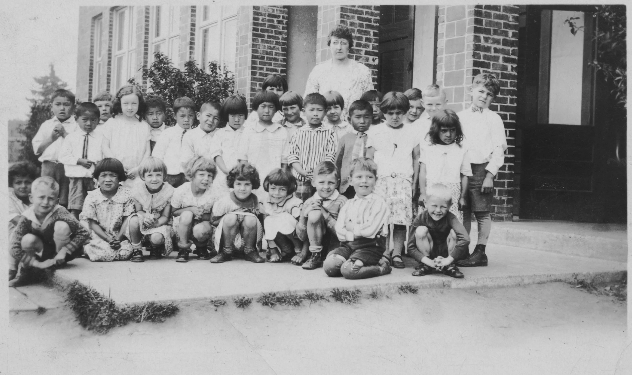
Northup got its school around 1890, located on what is today’s 116th Ave. N.E. north of Northup Way. In the 1960s an early resident, Hattie Goff Norman, recalled that “it was a very fine building with a belfry and large bell, cloak room, and ink wells in the desks.”  The first teacher, Margaret Yarno, commuted across the lake to Northup Landing from Seattle. In 1893 the school reportedly had 24 boys and 26 girls, although only about 16 children usually attended. In the early years teachers and their pupils put on evening programs—short plays, tableaux, recitations—for parents and the community.

Pupils of the Northup School with their teacher, Margaret Yarno, probably ca. 1893. (L82.050.025)

At one point the hills above Northup were being logged. A wooden chute, greased with axel grease, was built to shoot the logs downhill to the lake, and a gap was left at the point where the wagon road crossed it. A guard was stationed at the gap to insure that passersby wouldn’t be hit by a log hurtling down the chute, jumping the road, and diving into the water.

In 1905 the railroad finally came through Northup when the Northern Pacific finally completed its line between the Black River (southwest of Renton) and Woodinville.  One of two “stations” in the Bellevue area—the other was Wilburton—Northup had a depot in an old boxcar and a siding that could accommodate 50 railcars.  The line was primarily for freight and had originally been envisioned as a bypass around the congested railyards in Seattle. 

Perhaps the railroad’s printed schedule of September 1905 was partly responsible for the confusion that developed over the area’s name—was it Northrup or Northup? The schedule listed the station as Northrup.  In the 1930s road engineers furthered the error by installing road signs on “Northrup Road.”  Only in 1970 was the great-great-granddaughter of James Northup able to convince the Bellevue City Council of the correct family name, and the signs were finally rectified.

Heart of Northup in 1913, looking north up116th Avenue NE. Northup School with its belfry is visible on the upper right of the photo. Note the Northern Pacific’s boxcar “station” just beyond the railroad tracks. Courtesy Matt McCauley.

Today Northup is very much a lost landscape.  Benson Northup’s home still stood in 2007 when a cultural resources assessment was compiled in connection with the expansion of the South Kirkland Park & Ride. But today commercial and residential buildings occupy the site. Further to the east, the Northup School building became a private home in 1940, was  eventually purchased by The Little School, and was demolished in 2019.  But the rail corridor—without its tracks—survives as a section of Eastrail, which will eventually link Snohomish with Renton in a continuous biking and walking trail.  And Northup Way survives as well, continuing to wind around the hill to link the Houghton and Overlake districts.

Resources:

Seattle Daily Times, Sept. 23, 1905, p. 6

Kirklandhistory.org/1905-lwbl-ckc/1905-lwbl-history

Felix Bunel, MyNorthwest.com/157612, Nov. 1, 2019

Lucile McDonald, Bellevue: Its First 100 Years and an undated Journal American article

Vertical File, several photocopies of petitions pertaining to Road 85 (Northup Way)

John Caldbbrick, HistoryLink Essay 9621 re 1890 federal census

AMEC Earth and Environment Inc. “Cultural Resources Assessment of the South Kirkland Park & Ride Transit Oriented Development” Sept. 4, 2007

Eastside Stories: The Fleet that Never Was

No. 10 | June 12, 2019

Eastside Stories

The Fleet that Never Was

Eastside Stories is our way of sharing Eastside history through the many events, people places and interesting bits of information that we collect at the Eastside Heritage Center. We hope you enjoy these stories and share them with friends and famil…

Eastside Stories is our way of sharing Eastside history through the many events, people places and interesting bits of information that we collect at the Eastside Heritage Center. We hope you enjoy these stories and share them with friends and family.

By Margaret Laliberte

EHC Volunteer

The head of Yarrow Bay is a dreamy backwater on a sunny summer afternoon these days, but for a few months in the summer of 1945 the bay was the subject of a lively, often acrimonious, debate. Community and civic groups from around Lake Washington squared off against each other over a proposal by the US Navy to place more than three hundred ships for safekeeping between the marshy head of the bay and what is now Carillon Point.

This largely-forgotten slice of Eastside history happened as the war in the Pacific was coming to an end. In fact, on the day the atomic bomb was dropped on Hiroshima the steering committee of the Kirkland Commercial Club met to consider the proposal. (They supported it.)

The Navy needed a place to mothball part of its National Defense Reserve Fleet, smaller ships that could be readied quickly for sea duty. Navy planners identified Yarrow Bay, drew up blueprints for two north-south docks and received a $4,000,000 appropriation for construction. The shoreline would be filled in and the whole bay dredged. This, according to the Navy, would beautify the harbor.

The Seattle Chamber of Commerce, Kirkland officials and a few civic groups and local unions saw the chance to keep jobs as the Lake Washington Shipyard in Houghton slowed down with the end of the war. A local union official argued “It may be hard on the scenery, but you can’t eat scenery. The presence of those ships means jobs. Jobs mean that our kids will be fed.” (At first the figure going around was 2500 jobs, but later it was revealed that there might be only about 100 civilian jobs.; the rest would be Navy personnel.)

Yarrow Bay in 1936. Lake Washington Shipyard (now Carillon Point) near the top, and wetlands that would have been dredged at the bottom

Yarrow Bay in 1936. Lake Washington Shipyard (now Carillon Point) near the top, and wetlands that would have been dredged at the bottom

Supporters faced the vehement opposition of community groups around Lake Washington who feared the “industrialization” of the lake, water pollution, loss of views, and falling home values, to say nothing of all those sailors in town. Fred Delkin of the Hunts Point Community Club put it plainly: “Hunts Point doesn’t want the honky-tonks and other things that will go with [the ships] if a big maintenance crew is kept here.” The Yarrow Point Community Club sent flyers urging residents to protest to their senators, the Governor and Pentagon leadership.

Residents of Houghton, which was unincorporated at the time, felt that Kirkland and the Seattle Chamber of Commerce were selling them out. “They dropped this thing on us like a bombshell,” said Houghton resident Marcus Johnson. “I’d never think of buying a thing in Kirkland now,” said Mrs. Fred Gash. “We’d rather go all the way to Bellevue, and that’s what we’re doing.” The community had a much-loved beach park on the bay: 600 feet of waterfront where hundreds gathered on weekends to swim and picnic. It must have felt impossible to imagine the entire bay filled with military ships.

The Navy flew out two captains, one from the Navy Office of Public Information, to assess local sentiment at three meetings. The first, on Mercer Island, drew 400-500 people from 34 different community organizations bordering Lake Washington. Capt. Campbell’s patient assurances that bilge water and sewage would be safely piped ashore and not dumped into the lake did nothing to alter the vehement opposition of all the community groups. The captain asserted that the federal government had full authority over Lake Washington as a navigable body of water and could establish a moorage wherever it chose, although it would prefer to consult residents’ opinion. (He had the grace to admit that 98% of mail received back in Washington D.C. on the matter was in opposition to the plan.)

View from the northeast side of Yarrow Point, across Yarrow Bay to the Lake Washington Shipyard in 1939. The proposed Navy piers would have filled in this space.

View from the northeast side of Yarrow Point, across Yarrow Bay to the Lake Washington Shipyard in 1939. The proposed Navy piers would have filled in this space.

At the third meeting, held at the Seattle Chamber of Commerce and lasting three hours, sentiment was declared about evenly divided, though the meeting ended in some confusion as to whether the proper rules of procedure had been followed. The Navy captains were clearly weary. “This has been no vacation,” Capt. Campbell admitted. “I’ve heard some of the hottest air I’ve ever heard during my time here.”

Local meetings and debate continued through the summer, but at the end of the day, the Navy ran up its flag and withdrew. According to reminiscences of V.J. Berton, Houghton’s first elected mayor, the proposal was finally dropped because the Navy had concluded that acid in the lake’s water would rust the ships’ metal. The fleet was instead sent to the Columbia River; the Navy moored the ships at long concrete piers just east of Astoria at Tongue Point Naval Air Station until 1963.

View to the southeast from Yarrow Point in 1939. The Houghton side of the bay was sparsely settled until the 1950s.

View to the southeast from Yarrow Point in 1939. The Houghton side of the bay was sparsely settled until the 1950s.

Back on the lake, one of the most lasting consequences of the summer imbroglio was the feeling in Houghton that association with Kirkland was no longer in their best interests. In 1947 the community voted to incorporate, and Houghton remained a separate jurisdiction until 1968, when it consolidated with Kirkland. And Fred Delkin’s fears of honky-tonks was well-founded: zoning at the time was weak to non-existent. There would have been little to stop development of commercial establishments catering to the Navy operations.

The strong opposition to the Navy’s project might have surprised the early promoters of the Lake Washington Ship Canal who envisioned significant industrial development on the lake. But as residents of the growing region increasingly appreciated the exquisite beauty of the lake and its shoreline, industrial uses stopped making much sense.

Thanks to Margaret Laliberte, Eastside Heritage Center volunteer, for researching and writing this story. Margaret is a resident of north Clyde Hill , just south of Yarrow Bay. If you would like to contribute an article to Eastside Stories, contact us at info@eastsideheritagecenter.org


Learn more about the Eastside. Books available from Eastside Heritage Center include:

Lake Washington: The Eastside

Bellevue: the Post World War II Years

Our Town, Redmond

Medina

Hunts Point

Bellevue: Its First 100 Years


Our Mission To steward Eastside history by actively collecting, preserving, and interpreting documents and artifacts, and by promoting public involvement in and appreciation of this heritage through educational programming and community outreach.

Our Vision To be the leading organization that enhances community identity through the preservation and stewardship of the Eastside’s history.


Eastside Heritage Center is supported by 4 Culture

Eastside Heritage Center is supported by 4 Culture