Eastside Stories

Olga Carlson and the AYP

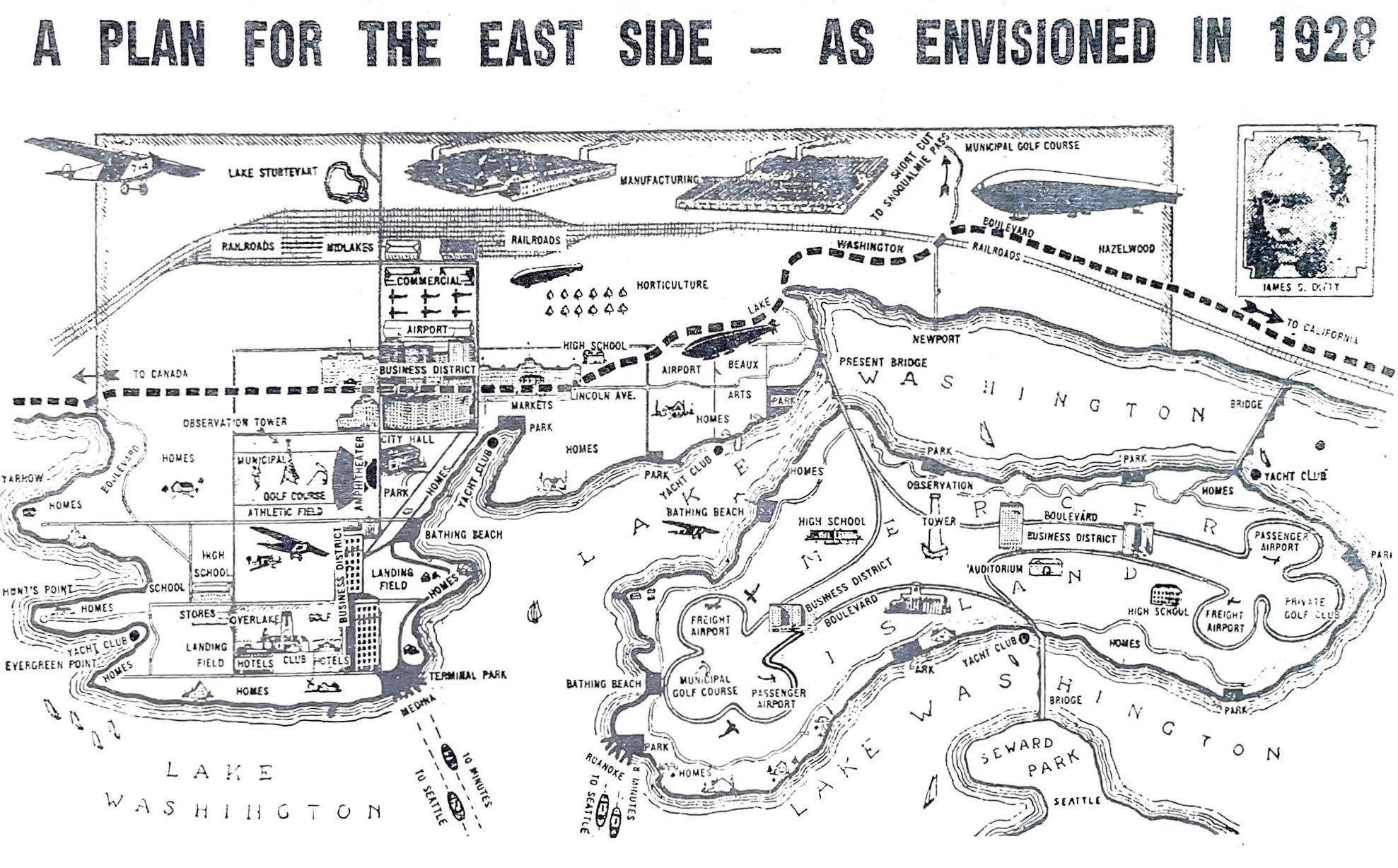
The Alaska-Yukon-Pacific Exposition (A-Y-P) is considered to be Washington’s first “world’s fair.”  The A-Y-P was mandated by the Washington State Legislature to provide a venue to display the advantages of living in this region.  It brought prosperity and riches to the Pacific Northwest and Washington state had much to be proud.

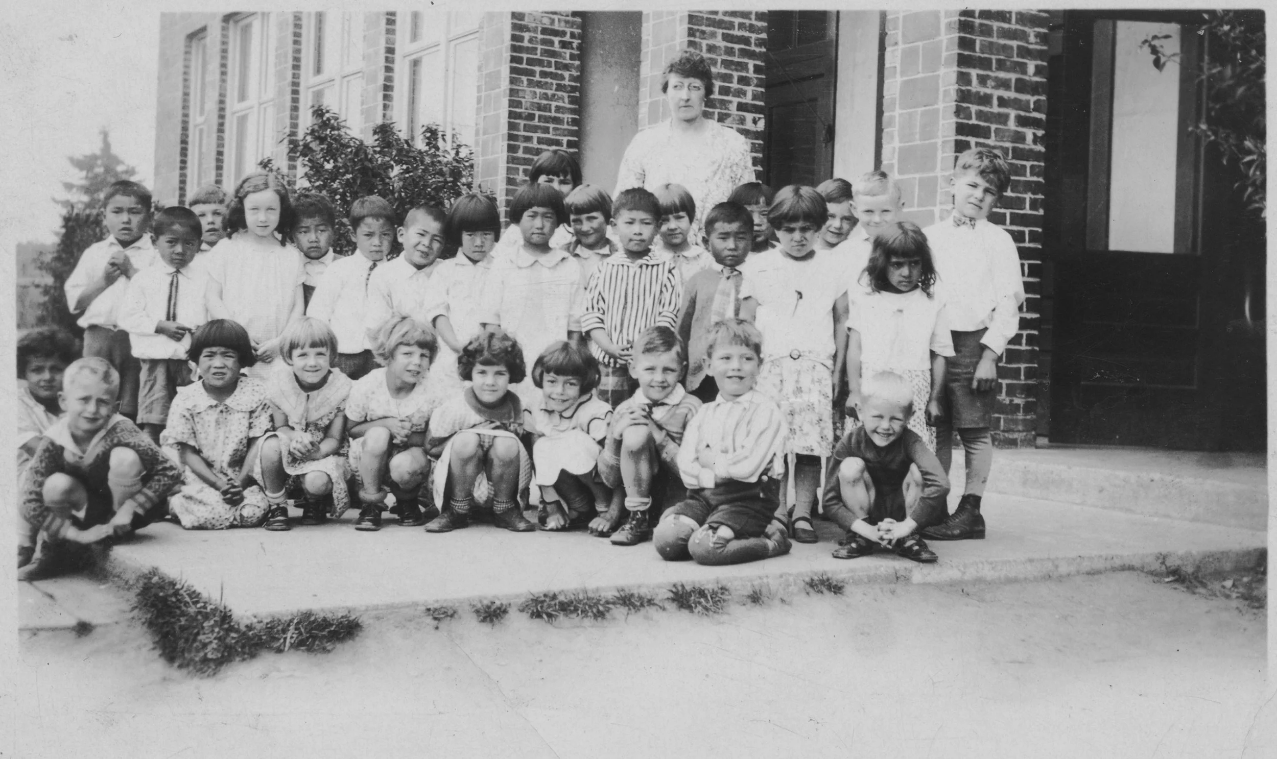
Nancy Larson and Olga Carlson, undated. (83.99.19)

The A-Y-P was held on the University of Washington campus between June 1 and October 16, 1909,  and hosted nearly 3 million visitors and tourists. Exhibits were presented by foreign nations, western states, and numerous business, scientific, artistic, and social organizations.

Every day at the fair was special!  Olga Carlson came with her family from what is now Happy Valley, Redmond, for Swedish Day.  She kept a diary and the following is her entry for the day:            

When I was going to Seattle to see the fair, Nancy, Elsie, Helen, and I wanted Grandpa to come with us.  We begged him to go but he just teased us.  We knew he would buy us something nice, at least he went with us to Seattle.

He took us to see a lion which was very big.  He took us for a ride in a boat on the Yukon River which I liked very much.  We went round three times.  Then he took us for a ride on a train, which frighted me very much.  It went up and down all the time and sometimes it would go through a tunnel.  He took us for a ride on a big wheel called a ferris wheel.  It went round three times and when it came to the top it would stop.  I enjoyed riding on it very much.

He brought us ice cream cones and many nice things which we liked very much.  We went to see the University Grounds two times.  First in the day time and then at night.  We heard many people sing.  We saw the parade.  One of my sister’s friends in Seattle was in the parade.  The day we went to Seattle was called the Swedish Day.
— Olga Carlson's Diary

Chinese Village during a parade, with Ferris wheel to the right, Pay Streak, Alaska-Yukon-Pacific Exposition, Seattle, Washington, 1909. University of Washington Libraries, Special Collections, AYP600

**Swedish Day was celebrated July 31st and had up to 40,352 admissions.  Festivities began with a parade in Swedish national costumes.


Resources: 

Eastside Heritage Center, Lester Olson Collection 

Alaska-Yukon-Pacific  Exposition : A Timeline History:  Alan Stein, Paula Becker and the HistoryLink Staff, 2009

University of Washington Special Collections

4Culture AYP Curriculum Project 2009

The Lake Sammamish Harbor Seal

Strange as it may sound, there once was a seal who lived 25 years in Lake Sammamish. Lovingly referred to as “Butch”, the 250 pound harbor seal was first spotted in 1950. At first, locals thought he might be a muskrat or an otter, but his size quickly ruled out those options. Harbor seals, unlike other pinnipeds, are known to live in in low-salinity waters, like rivers and estuaries. But how did Butch get to Lake Sammamish in the first place?

It is possible that Butch made his way from Puget Sound, through the Hiram M. Chittenden Locks to Lake Union and then Lake Washington, and finally up the Sammamish Slough. There have been other seal sightings in Lake Union and the north end of Lake Washington. There is just one flaw in this explanation; Butch was wearing a collar. It may be more likely that Butch was a pet someone released in the lake once they tired of him.

Butch the seal being lured ashore by Shannon, the golden retriever, in order to capture him for medical treatment (2003.022.006b)

In 1961, Jack Jarvis of the Post-Intelligencer reported that Butch was outgrowing his collar. It was cutting into his neck and blood was found on the dock where he usually slept. Some members of the community worried that this wound would make the seal more aggressive, while others maintained that he was a friendly (albeit mischievous) creature.

There was a brief effort to establish a Save Butch Fund”, designed to facilitate capturing and rehoming Butch at Woodland Park Zoo. This plan was ultimately abandoned due to unknown cost for such an undertaking and the risks associated with tranquilizing the seal.

Butch being netted and taken for medical treatment in 1975 (2003.022.005b)

Over the years, Butch became a known and mostly accepted part of life on Lake Sammamish. He would occasionally bump up against swimmers or wave a flippers at folks on the docks. He established a sort of friendship with several lakeside dogs, although the dogs may not have found his style of “play” very fun. He would sometimes pull a dog a short ways under the water before releasing them to swim back to the surface.

In September of 1975, Butch nearly drowned a dog named Shannon when he dragged her from a dock and into the water. This incident, and a few others, indicated that the seal was becoming a threat to the community. The collar around his neck was still a concern and he likely needed medical treatment as well. Department officials lured Butch from the water with Shannon, netted and sedated him for transport. The aim was to release him into Puget Sound when he had recovered.

Butch the seal netted for medical treatment by the Washington State Dept. of Game in 1975 (2003.022.004b)

Unfortunately, he never made it to Puget Sound. Butch died September 12, 1975, from complications of old age. The collar wound was the most severe problem, which had constricted his breathing. Butch’s skeletal remains were given to the Museum of Natural History at the University of Puget Sound where they were to be used for long-range mammal comparison research.

Resources

Campbell, N. P. (n.d.). Butch the lake sammamish seal . Butch the Lake Sammamish Seal by Nan P. Campbell. Retrieved September 20, 2022, from https://www.historylink.org/File/5542

Do harbour seals (phoca vitulina) housed in fresh water need to be supplemented with salt? VIN. (n.d.). Retrieved September 20, 2022, from https://www.vin.com/apputil/content/defaultadv1.aspx?id=3864854&pid=11257&print=1

Harbor Seal facts. SeaDoc Society. (n.d.). Retrieved September 20, 2022, from https://www.seadocsociety.org/harbor-seal-facts

Team, C. (2018, November 23). Butch the Harbor Seal Lives 25 years in Lake Sammamish. Friends of Lake Sammamish State Park Website. Retrieved September 20, 2022, from https://www.lakesammamishfriends.org/blog/2018/11/21/harbor-seal-lives-25-years-in-lake-sammamish

Eastside Heritage Center Archives

Fred Eitel and Lochleven’s Earliest Days

BY Margaret Laliberte, EASTSIDE HERITAGE CENTER VOLUNTEER

Swimmers at Rogers Beach in Meydenbauer Bay in the 1920s.  It is likely that some of them may be members of the Eitel family. (2001.114.026)

A note on the back of a photo from the 1920s showing swimmers relaxing in Meydenbauer Bay identifies their location as "Rogers Beach, 96th, west of Eitel Beach.”  Where could that be?  The Polk Eastside Atlas of 1945 identified parcels owned by Fred J. Eitel and another by Sarah Rogers, lying between the bay and Lake Washington Boulevard, south of 96th Ave. N.E. and west of what later became the first Meydenbauer Beach Park in 1953. That was the heart of the Lochleven neighborhood, which owed its existence to Fred Eitel and his co-officers of the Bellevue Land Company, William Norris and F. A. Sutphen. By 1906 Eitel had purchased several parcels and conveyed them to the newly incorporated company. A plat map was filed with the county in 1907.

Plat of Lochleven. The subdivision‘s boundaries are Meydenbauer Bay and streets now known as  92nd Ave. N.E., N.E. 8th St. and 100th Ave. N.E. (Dawes 2003.003)

At that time Eitel was already an up-and-coming property developer in Seattle.  In 1904, when the massive Second Denny regrade project was underway on Second Avenue, he and his brother David had begun building the six-story Eitel Building on the corner of Second Avenue and Pike Street. Completed in 1906, it housed the largest passenger elevator in the Northwest at the time. A photo shows the building under construction while Second Avenue just to the North was only a track winding among piles of dirt and debris.   The building was one of numerous substantial new buildings in the developing area the Seattle Daily Times called a “handsome retail district.” In coming years Fred Eitel owned significant buildings in the city’s core and in the newly reclaimed “tide lands.” In an ad for a real estate investment firm in which he was a shareholder, Eitel was described as “a real estate expert and man of affairs.”

Over in Meydenbauer Bay the Lochleven development got underway in 1906, advertised frequently in both the Seattle Daily Times and Post-Intelligencer newspapers. Initially the developers had a grand vision. A Times article described “a broad esplanade for the waterfront with a heavy retaining bulkhead, concrete walks, parks, parking strips, piers, boat houses, graded streets and a water system.” This would be a district of attractive homes from which apartments and businesses would be barred and a single distinctive “English” style of architecture would prevail throughout. Another ad assured readers that the developers were catering to “discriminating buyers who wish not to be surrounded by shacks.” An illustration showed a large dock with a Craftsman-style pavilion. Over the summer free excursions by steamer were offered. Potential buyers were cautioned not to expect to see the old English houses or Kenwood Boulevard along the waterfront—yet. (A few months later promised improvements were apparently scaled back, as ads mentioned only graded streets, cement sidewalks and water mains.)

Lochleven’s marketing efforts alternated between promoting an attractive residential development and suggesting downright land speculation. The ship canal and locks were on the horizon—construction began in 1911—and even in 1906 newspaper ads suggested that the lowering of the lake would probably add 50 to 100 of land to Lochleven waterfront parcels.  As the so-called Eastern shore built up, property values would soar, readers were assured.

Perhaps the most unusual example of speculation was the sale of a parcel of Lochleven waterfront property in 1919 to the American Pacific Whaling Company. A wharf was built, and the company’s ships in the Alaska whaling industry overwintered there until 1942.  (The parcel later became part of today’s Meydenbauer Bay Park.) The company founder’s grandson reminisced that when the company moved to town, Bellevue “was way out in the sticks and there was no objection to a commercial enterprise in Meydenbauer Bay.”

Eitel family home in Lochleven in 1922, looking west towards Medina.  The steamer on Meydenbauer Bay is the “Atlanta,” just one of the small ferries servicing East shore communities. (Dawes 2003.003)

Lochleven developed slowly over the years.  In 1918 Eitel and his wife Ruby moved their family of four children to their new home there. They became active members of the growing Bellevue community. Ruby was active in the Bellevue Women’s Club in the 1920s, the girls in the Junior Division of the Fruit and Flower Mission (which ultimately became Bellevue LifeSpring). Fred served on the board of the school district and was a founding officer of the Bellevue Water Company. In 1938 he died of injuries from being hit by a car as he stepped from the bus on his way home. He was 71.  Ruby had died of illness nearly three years earlier.

Fred Eitel’s legacy is evident on both sides of the lake today.  The Eitel Building still stands, having survived years of deterioration, boarded-up windows, and a threat from the City to demolish it. Its latest owners completely restored it, to the tune of $16 million, and it is now the State Hotel, from whose rooftop deck guests look over the Pike Place Market to Elliott Bay.  Lochleven is still a quiet green neighborhood.  It lacks the beachfront promenade—and for the most part the promised paved sidewalks. It has an active community association, though.  Voting membership is based on residence within the boundaries of the original 1907 plat map.

Resources:

EHC archives (Dawes Collection)

Seattle Daily Times May 27, 1904, August 21, 1904, February 12, 1905, May 20, 1906, April 16, 1907, Sept. 10, 1909, November 9, 1938

Seattle Post-Intelligencer June 7 and 17, 1906, July 11, 13, and 29, 1906, April 5, 1936

Bellevue Reporter October 14, 2011 (Heritage Corner)

Wikipedia article “Eitel Building”

Univ. of Wash Special Collections, photograph by Arthur Churchilll Warner 1904 , PH Coll 273.168

Oral History interview with William Schupp Lagen, EHC files

Steve Johnston, “Whale Festival in Bellevue Honors Oldtime Industry,” Seattle Times, March 1, 1991

Bellevue Dairy Farms

BY Barb williams, EASTSIDE HERITAGE CENTER VOLUNTEER

Less than 100 years ago NE 8th Street in Bellevue was a dusty dirt cow path bordered by bracken ferns and meadow grasses where children lead the family cow home for milking. Presently (2022) the former cow path is a hard-surfaced road bustling with activity and lined with high-rise buildings.

L80.057.001 - Children and cow on path, Bellevue 1928

In the early days, many families had a cow, or several, and children were accustomed to seeing the cream rise to the top of the milk sitting in pans on the pantry shelf. Making butter from the cream was a way women could earn money. Today, many children think dairy milk comes in containers from the grocery store. Thanks to the City of Bellevue, the historic Twin Valley Dairy Farm at Kelsey Creek Farm Park remains a farm where the public can learn about dairy farming and its importance to life on the Eastside. Through hands-on activities and seeing the farm animals, they experience a touch of farm life. The farm began in 1921 when W.H. Duey cleared the land, built a barn and started a dairy. Home-churned butter and milk were delivered to various destinations in a truck driven by Mrs. Duey. The family operated the dairy until 1942.

In a 1913 promotional labeled, “Bellevue on Lake Washington”, a sentence read, “This district is particularly adapted to dairying, the climate, soil and other conditions being ideal for this industry.” And so it was! Dairies sprang up around the region including the successful research Carnation dairy, Highland Dairy Farm, Phantom Lake Dairy, Benhurst Dairy, Twin Valley Dairy Farm, Marymoor Farm and many others. In June of 1929, The Northwest Dairyman and Farmer publication claimed that Bellevue was home to one of the most efficiently run dairies in King County. That dairy was the Benhurst Dairy run by Ben Silliman. His herd of high grade pure bred Holsteins took first place that January for producing 1111.8 pounds of milk and 37.6 pounds of butterfat. The queen of the herd was Pearle Pietertje producing 2,495 pounds of milk and 77.3 pounds of butterfat between January and June. Not only were the cows of high quality, but also the equipment. Good hand milkers were often difficult to find which slowed the production. Ben Silliman had transitioned to effective milking machines which added to his success.

98.018.016 - Ida Swanson milking Hanson's cow

John and Bertha Siepmann moved from Indiana where he had worked in the coal mines. In 1904, they purchased 60 acres in the Highland area near the corner of 148th Avenue NE and NE 24th. They built a house and began to farm. Later their son, George, started the Highland Dairy Farm. Once a week they travelled by horse and wagon to sell butter and eggs in Seattle. Their daughter, Christina, married Chris Nelson who owned and started the Phantom Lake Dairy Farm in 1922. The Dairy was located at 159th SE and SE 16th and operated for over 25 years. Several people drove for the dairy delivering milk. William Ottinger was one of them. He was employed for thirty-six years as a driver for several dairies. His first job was in 1918 when he drove a horse and wagon for Downey’s Highland Dairy on Clyde Hill. At times his route covered twenty-two miles. During his employment, horses and wagons were replaced by trucks, metal gallon milk cans by glass bottles and the bottles by paper milk containers. Mrs. Ottinger remembers as a girl it was her job to clean the milk/cream separator parts; a complex machine. She said, “I didn’t mind washing dishes, but the separator was the bane of my life.”

L90.024.002 - Highland Dairy Farm truck

Phantom Lake Dairy lid, courtesy of Dale Martin

Pat Sandbo remembers, “Our cow was named Dolly, a nice Jersey who provided us with more rich milk than we could use. My mother used to skim off the thick cream and we would put it on the strawberries for breakfast. We didn’t know about cholesterol then. Dolly used to get out of her pasture, but my father always knew where to find her. She headed for the school yard and we used to joke about our educated cow.” Pat grew up in Bellevue where she later taught elementary school. Perhaps her cow, along with others from local dairies, provided rich cream for the whipped cream that topped the scrumptious strawberry shortcakes; the centerpiece for the first Bellevue Strawberry Festival (1925). Japanese farmers provided the strawberries. Women from the Women’s Club baked the shortcakes. And to top it off, in the 1940s Mina McDowell Schafer was making her delectable Chocolate Truffles with heavy cream, lots of butter and tested by Diana Schafer Ford, later to become Miss Washington! We owe much to the dairy farmers and their cows. 


Resources:

Lucile McDonald’s Eastside Notebook, c1993, Marymoor Museum

Culinary History of a Pacific Northwest Town by Suzanne Knauss, c2007  Suzanne Knauss

Images of America, Bellevue Post World War II Years, c2014 Eastside Heritage Center, Arcadia Publishing

Bellevue Its First 100 Years by Lucile McDonald, c2000, The Bellevue Historical Society

Eastside Heritage Center archives

The Sammamish Slough Races

By Steve Williams, EASTSIDE HERITAGE CENTER VOLUNTEER

Before “Seafair” the Eastside event of the summer was the “Sammamish Slough Race”. Starting in the spring of 1928 and running for another 48 years, motorboats raced each other up and down the 13 mile narrow 'river' connecting Lake Washington and Lake Sammamish. As the map shows, it was a torturous route with hazards including 63 sharp turns, bridge pilings, sandbars and occasional floating logs. Steve Greaves, who started racing at age 14 and went on to set over 30 world and national records, said “There was really nothing like it in the country. Even today most will tell you it was one of their favorites. It was certainly the craziest. I remember coming around a bend going through Redmond and having to dodge a cow getting a drink of water.”

KFKF Radio flyer, with Sammamish Slough power boat race route, April 1969 (2004.015)


An estimated 40,000 spectators watched from bridges and river banks on the tight corners where wild crashes and side flips often occurred. Sometimes spectators would help racers get their boat back in the water, or if it couldn't be repaired, hand the driver a beer and invite him to watch the race with them. In later years there were five different classes of boats and over 100 entries, some from Tacoma, Hoquiam, and even Oregon. (The number of spectators probably doubled). With the development of small hydroplanes speeds hit 80mph, but nearly a third of the racers often failed to finish due to crashes or mechanical problems. Spectators noted the special 'race smell' of the alcohol fuel burned by the hydros, and said that “hearing the boats coming long before seeing them turn the corner added to the excitement.”

1962 Bob Carver / Seattle Times (EHC Vertical Files)

According to Seattle Times reporter Craig Smith, “A different division would start every five minutes from Lake Washington and head upstream. Waiting with cameras poised at the most dangerous turns were newspaper photographers and cameramen from Movietone, who would film crashes that would be shown in the nation's theaters.” Howard Anderson, a national VP of the American Power Boat Association said, “I don't think there was a race like it in the nation, ever.” Dick Rautenberg, a competitor from Bothell agreed, saying, “That was the most fun of any racing we've done.”

1963 Seattle Times (EHC Vertical Files)

Another significant local event happened in 1953 when the Golden Water Ski Club teamed up with the Seattle Outboard Association to race towed skiers up and down the Slough. The upstream inning time was 24:37 minutes, while downstream with the current, slow as it was, cut the time to 22:43. Of course all the turns made it fun for the skiers and even more challenging for the drivers.

The Slough itself had a long and storied boating history. Native canoes traveled up and down, but were also used in gathering plant material, and in fishing and hunting waterfowl. Small scows and narrow steamboats arrived with settlers in the 1880's. (A few even had hinged smokestacks that could be folded down when going under low bridges). For half a century, logs were floated or towed downriver to sawmills - during spring floods havoc occurred as log-jams blocked the river and farmers fields were covered with water for months at a time.

In 1964 – 1966 it all changed when the U.S. Army Corps of Engineers dredged and widened the Slough. The 3.8 million dollar flood control project took out 30 miles of 'squiggles and kinks' and straightened it to 10 miles of 'steep-sided ditch.' A concrete weir, or submerged dam, at Marymoor Park now keeps Lake Sammamish at a relatively constant level, and there is a nice paved bicycle trail running along the high bank of the slow moving 'Slough'. The thrill is gone, but the excitement and challenge of the “Race” will long be remembered as the Eastside's precursor to “Seafair.”

Sources:

10/21/1999 Seattle Times article “Old river new routes” by Peyton Whitely.

4/15/1994 Seattle Times article “Unpredictable 'Slough Race' a bygone rite of spring” by Craig Smith.

3/24/1963 Seattle Times article “The Taming of the Slough” by Eileen Crimmin.

5/2013 newsletter of the Redmond Historical Society “Showcasing Our History: Sammamish River Races”.

4/2014 newsletter of the Redmond Historical Society “Northwest Original: The Sammamish Slough Race”.

7/1953 magazine; “Sea and Pacific Motor Boat” report of Russell Swanson.

2015 book; “Lake Sammamish Through Time” by Kate N. Thibodeau.

3/30/1977 Sammamish Valley News, article by Wendy Reif  "Slough Race bottoms out"

Chicken Farms on the Eastside

By Barb Williams, Eastside Heritage Center volunteer

Pioneer families often raised chickens. The birds were inexpensive to feed, produced eggs for baked goods, meat for the table and a source of feather-down for pillows and quilts. Many of the Eastside pioneers raised chickens for their individual needs.

Dwight Skinner was one of several Eastside residents who raised chickens commercially. In 1912, Dwight and Nell Skinner bought a 40-acre tract of land on the Highland-Larsen Lake Road. The land had belonged to the Churchills and included a home, barn, feed room and two-story chicken house. Dwight suffered from heart problems and was often unable to work. He had 2,000 to 5,000 chickens whose eggs, he figured, would help to supply the income he needed.

L 86.024.004 - Mr. Harmon feeding chickens at Morelli chicken ranch, 1918

The Morelli brothers; Alfonso, Martin, Silvio and Tito immigrated from Italy and bought land along 148th Avenue in Redmond. They ran a thriving chicken ranch from 1915 to 1973. It was the biggest of its kind on the Eastside at the time. They had 15,000 chickens who had the run of long elevated chicken houses. The business became such a success that they operated through a middle-man and never had to advertise. In the 1940s, they pioneered in the use of electricity by installing timed electrical lights in the henhouses. The timers turned on the lights at 4 a.m. extending daylight hours, egg-laying time and egg production. In the 1970s, some of the Morelli land across 148th was developed into private homes. Silvio passed away in 1979 and Microsoft bought the land in the 1990s with the stipulation that Silvio’s wife, Albarosa, could remain in the family home as long as she wanted. She passed away in 1999 and Microsoft proposed turning her home into a library.  

For nearly 40 years around 1922, 116th Avenue NE between Main Street and NE 8th in Bellevue was known as Lebanese Valley because most of the residents were from Lebanon. George Waham was a resident. He bought five acres and started a farm on which he raised chickens, a cow, rabbits, fruits and vegetables. During the Depression he and his wife fed other people including their large family.

OR/L 79.79.342 - Chicken in front of farm building, Willowmoor.

In 1927 two black men, A. Cunningham and C. James, came from Seattle to become the proprietors of the Wake Robin Lodge located in Enatai. Their business was the first on the Eastside to be operated by black people. The Lodge became famous for the fresh food raised on-site, especially its chicken dinners. Fruit trees and a large garden supplied produce. Long chicken coops stretched along the south side of the property with a small dairy nearby. Mr. Jones tended the chicken ranch which consisted of a  number of chicken houses. He raised white leghorns. He lived with his wife onsite in a home under the water tank. The water, used for the chickens and lodge, was pumped uphill from a well on Lake Washington Boulevard. Due to the Depression, the Lodge closed in 1934. 

Presently chickens can be found at Kelsey Creek Farm Park owned and managed by the City of Bellevue. Breeds of chickens are selected for their personalities, egg color, feather color and characteristics appropriate for public viewing. Wyandotte, Barred Rock, Ameraucana and Bantam are some of the breeds selected. The purpose of the farm is to educate people about animal husbandry. Chickens often feature in events and classes taught by farm staff. Some chickens are good egg-layers, others better for meat and some are dual-purpose. Historically they have connected with humans for a long time.

Sources:

Eastside Heritage Center archives

Carla Trsek, Kelsey Creek Farm Park staff

Culinary History of a Pacific Northwest Town by Suzanne Knauss.  2007

The Lake Washington Scenic Highway

BY margaret Laliberte, EASTSIDE HERITAGE CENTER VOLUNTEER

W.E. LeHuquet, owner and editor of Bellevue’s Reflector newspaper liked to call it the Lake Washington Scenic Highway. The Seattle Star newspaper preferred Lake Washington Boulevard.  Both were referring to the string of streets and highways eventually stitched together to form a continuous 52-mile route circling Lake Washington. In an opinion in 1919 urging readers to support the completion of a final four-mile segment between Bellevue and Newport, the Star exclaimed “Do you realize that this boulevard, when completed, will give to Seattle the most beautiful circuitous trip in the state and that it will be one of the principal scenic attractions of King county”?

L 84.028.1 - Ditty City 1928 illustrated map of Bellevue - John Ditty's vision of the future.

The final stretch was indeed completed, and on June 5, 1920 an autocade traveled from Seattle’s County-City Building around the north end of the lake to Bellevue’s Wildwood Park near Meydenbauer Bay for festivities showcasing speeches by officials of the Automobile Club of Western Washington as well as past and current county commissioners. The Bellevue District Development Club had decorated the town with flags and banners, and Eastside ladies’ committees served coffee, lemonade and sandwiches. The event was hosted by the Reflector.

During the 1920s and 30s, the Seattle Star sponsored an annual 52-mile walking contest around the lake. Contestants who decided that by the time they reached Bellevue they’d  had enough were offered transportation across the lake back to the City.  In 1928 the male winner of the race finished the entire course in 9 hours, 24 minutes.  His first-place cash prize of $250 would be worth about $4,000 today. The winning woman, a Monroe teacher, finished in 13 hours, 11 minutes. (The Seattle Times announcement did not mention whether she too received a prize.)

It is not likely that the all the roads constituting the entire route were ever known uniformly as  Lake Washington Boulevard.  In Seattle the Olmsted firm laid out the section running from Montlake to Seward Park along the lake shore; it is still Lake Washington Blvd.  On the Eastside in 1945 a long stretch of road called Lake Washington Boulevard ran north from Renton along the lake shore to Factoria.  It turned west along S.E. 32nd (which no longer exists there) and then angled diagonally across Mercer Slough to where the Winters House stands today.  It followed 104th Ave. NE to today’s Main Street, where it ran west along the lake to 84th Ave. NE.  At NE 28th it turned east to run along the south of Hunts Point and Yarrow Point on what is today called Points Drive to an intersection at Northup Way.  Continuing north towards Hougton it was called Lake Washington Blvd until it reached the Bellevue-Kirkland boundary.

From today’s perspective, one wonders why the route didn’t simply run due north along present Bellevue Way/104th Ave. N.E. Early developer James Ditty thought the same thing.  According to local history writer Lucile McDonald, when what later became Bellevue Way was just a “cow trail” called Peach Street in the late 1920s, Ditty bought 38 acres around today’s intersection of Bellevue Way and N.E. 8th St.  He granted King County an easement across his property, and in 1930 the newly paved road running north toward Kirkland was renamed Lincoln Avenue.

Remnant stretch of Lake Washington Boulevard

Ditty’s property became the new nucleus of Bellevue’s commercial district. But Lake Washington Boulevard continued to meander closer to the lake shore. An almost overgrown remnant of the old paved road can still be walked between Bellevue Way and N.E. 35th Place in Clyde Hill, just south of the sound wall of SR 520. In summer prolific brambles offer up ripe blackberries for the picking.

References

Reflector editions (is this kind of resource just called EHC archives?)

Seattle Times May 20, 1928

Seattle Star, July 26, 1919 (graphic of LWB route)

Lucile McDonald, Bellevue, Its First 100 Years

Kroll Eastside map book 1945

HistoryLink Essay #10244, “Lake Washington Boulevard”

Holly Farms in Bellevue

BY Barb williams, EASTSIDE HERITAGE CENTER VOLUNTEER

Who would think that Bellevue in the 1920s had the most extensive holly farm in the United States? But it did thanks to the patience and vision of Edward P. Tremper and Dr. C. A. Holmes. Patience because it takes 15 to 18 years before a crop becomes commercially productive. Tremper ran an insurance business and Dr. Holmes was a dentist. They were neighbors in Seattle. In 1900, Tremper bought 10 acres of land on Yarrow Point and moved there two summers later. He had the unprecedented idea of planting a holly orchard which he did in 1902. He ordered 1,000 young plants from France, planted them and waited for them to mature. His holly farm was the first on Puget Sound.

Ilex aquifolium

Dr. Holmes liked the idea and bought 10 acres at 111th Avenue SE on the east side of Enatai. After he died in 1933, Tremper acquired the land thus making the Tremper family holly plantation the biggest in Washington State, according to the 1929 issue of Nature Magazine. By 1930, the Tremper family planted five additional acres on the east side of 92nd using a variegated type of holly. The farm continued to expand and grow boasting 3,000 trees by the 1940s. At this time Tremper’s three sons were running the business. During the busy winter holiday months, they hired many packers and cutters, the majority of whom were Japanese farmers. The Trempers also bought holly from a farm on Mercer Island and shipped gift boxes all over the country.

As Tremper continued his experiment, he discovered that he only needed a few male(bull) trees and therefore planted mostly female trees. Both sexes were needed for pollination, but it was the females that produced the desirable red berries used for decorations, especially at Christmas time. However when many of the Japanese were forced to leave the area during World War II, it became difficult to find workers. Added to this, weather conditions produced overtime hours which resulted in additional wages. Property taxes increased and by 1946 the Trempers quit operating the Enatai property. They closed the original farm at Yarrow Point in 1956.

Ilex aquifolium

Holly trees can still be found in Bellevue. The evergreen plant continues to be a favorite for winter holiday designs and decorations. Although the berries are toxic to humans and most household pets, they are a winter food resource for birds such as robins. As a shrub-like tree, it can grow in height from foot-high dwarfs to fifty-foot tall trees. Due to its prickly evergreen leaves, it provides a safe, warm place for nesting birds in winter when deciduous trees lack leaves. In England, the holly is often used in hedgerows to contain farm animals or to separate one area from another. The prickly tough leaves provide a formidable barrier.

The holly is one of the most respected and loved trees in Celtic lore. A holly wreath was worn as a crown by Celtic chieftains for good luck. Traditionally, newborn babies were protected from harm by bathing them in water from the leaves. The tree represents peace and goodwill. Due to its resistance to lightening, it was planted near houses to protect people from lightening strikes. The Druids also believed in it’s protective powers. Their legends tell how the leaves, if brought into the house during the winter months, would provide shelter and warmth for fairies who would then be kind to those who lived in the home.


Resources:

Eastside Heritage Center archives

Lucile McDonald Journal American article 4/6/1977 “Holly sprouts left from pioneer farm”

Online:  Holly Tree Meaning,  The Symbolic Significance of Holly,  “Bellevue’s history is rooted in rich farmland” article by Sherry Grindeland

Sunset Western Garden Book,  1995.

The Early Community at Northup

BY margaret Laliberte, EASTSIDE HERITAGE CENTER VOLUNTEER

Drivers negotiating the SR520/I-405 interchange can be forgiven for not realizing that they are passing right over the site of the little district of Northup, which developed in 1890s. Virtually all of it has been erased from today’s landscape.

In 1884 or ’85 James Northup recorded his land claim at the head of what is now called Yarrow Bay.  He and his wife Almira built a cabin on property.  They were joined by their son Benson, who in 1889 built a larger house very close to where today’s Burgermaster Drive-In restaurant stands. At some point the Northup Dairy and Cherry Farm existed on the property.

Florella and Benson Northup, 1912. (L85.2)

When the Northups arrived,  King County’s population was exploding: it grew from 6,910 in 1880 to 63,989 in 1890, an increase of 826%!. Just to the north, beginning in 1888, Peter Kirk and Leigh S.J. Hunt planned to industrialize the area with a huge iron and steel mill , a project that soon collapsed. But Northup’s neighborhood was still deep woods and scattered families.  There was never a town, really, more a collection of essential community services that sprang up over the early years. The dock on the bay became known as Northup Landing.   A Methodist Episcopal church was founded in 1888.  A post office opened in July 1892 and lasted until 1897. Local resident Mrs. Ann Dunn was postmaster.  Apparently at some point there was also a store.

Perhaps as early as 1879 a group of local settlers had filed a petition with the King County Commissioners of Washington Territory for a public road to run east and intersect with the only north-south road then existing that connected the area with the mines at Newcastle (now 140th Ave. N.E.).  At first the road apparently ran due east from the bay.  In 1886 its route was altered to run southeast so as to avoid the steep section over “Fagerburg Hill.” Originally called Road 85, it became known as Northup Way.

Northup got its school around 1890, located on what is today’s 116th Ave. N.E. north of Northup Way. In the 1960s an early resident, Hattie Goff Norman, recalled that “it was a very fine building with a belfry and large bell, cloak room, and ink wells in the desks.”  The first teacher, Margaret Yarno, commuted across the lake to Northup Landing from Seattle. In 1893 the school reportedly had 24 boys and 26 girls, although only about 16 children usually attended. In the early years teachers and their pupils put on evening programs—short plays, tableaux, recitations—for parents and the community.

Pupils of the Northup School with their teacher, Margaret Yarno, probably ca. 1893. (L82.050.025)

At one point the hills above Northup were being logged. A wooden chute, greased with axel grease, was built to shoot the logs downhill to the lake, and a gap was left at the point where the wagon road crossed it. A guard was stationed at the gap to insure that passersby wouldn’t be hit by a log hurtling down the chute, jumping the road, and diving into the water.

In 1905 the railroad finally came through Northup when the Northern Pacific finally completed its line between the Black River (southwest of Renton) and Woodinville.  One of two “stations” in the Bellevue area—the other was Wilburton—Northup had a depot in an old boxcar and a siding that could accommodate 50 railcars.  The line was primarily for freight and had originally been envisioned as a bypass around the congested railyards in Seattle. 

Perhaps the railroad’s printed schedule of September 1905 was partly responsible for the confusion that developed over the area’s name—was it Northrup or Northup? The schedule listed the station as Northrup.  In the 1930s road engineers furthered the error by installing road signs on “Northrup Road.”  Only in 1970 was the great-great-granddaughter of James Northup able to convince the Bellevue City Council of the correct family name, and the signs were finally rectified.

Heart of Northup in 1913, looking north up116th Avenue NE. Northup School with its belfry is visible on the upper right of the photo. Note the Northern Pacific’s boxcar “station” just beyond the railroad tracks. Courtesy Matt McCauley.

Today Northup is very much a lost landscape.  Benson Northup’s home still stood in 2007 when a cultural resources assessment was compiled in connection with the expansion of the South Kirkland Park & Ride. But today commercial and residential buildings occupy the site. Further to the east, the Northup School building became a private home in 1940, was  eventually purchased by The Little School, and was demolished in 2019.  But the rail corridor—without its tracks—survives as a section of Eastrail, which will eventually link Snohomish with Renton in a continuous biking and walking trail.  And Northup Way survives as well, continuing to wind around the hill to link the Houghton and Overlake districts.

Resources:

Seattle Daily Times, Sept. 23, 1905, p. 6

Kirklandhistory.org/1905-lwbl-ckc/1905-lwbl-history

Felix Bunel, MyNorthwest.com/157612, Nov. 1, 2019

Lucile McDonald, Bellevue: Its First 100 Years and an undated Journal American article

Vertical File, several photocopies of petitions pertaining to Road 85 (Northup Way)

John Caldbbrick, HistoryLink Essay 9621 re 1890 federal census

AMEC Earth and Environment Inc. “Cultural Resources Assessment of the South Kirkland Park & Ride Transit Oriented Development” Sept. 4, 2007

Hans Miller and Albert Burrows Cabins

The Hans Miller and Albert Burrows cabins will be the final article on “Bellevue’s Early Cabins”.  They are located in Bellevue Parks, but not open to the public.  Hopefully, at some future time, Eastside Heritage Center will be able to do outdoor programs at these sites.

Burrows Cabin, Rody Burrows on porch. (OR/L 79.79.533)

The Burrows cabin is the oldest of the five featured structures.  In 1882, Albert Burrows filed a land claim on the east side of Lake Washington and built a 14 x24 cedar log cabin, chinked with clay and moss. Albert was a Civil War veteran from Iowa and this land was part of the Homestead Act. The area became known as Burrows Landing, just south of Chism Park.

In the 30s, the cabin was moved to Bellevue Way, near Bellevue Square, and later, in 1946, to a site on 112th Ave. NE.  It remained a private residence until 2016 when it was transported to Chism Park. It is thought to be located near its original site and can be seen on the upper lawn of the park.

Miller Cabin at Robinswood Park, 1976. (L88.064.006)

The Hans Miller Cabin is found at Robinswood Park, its original location.  The cabin was built in 1884 by a settler from Denmark, Hans Miller, and built quickly for immediate shelter.  He also built a log barn a few years later.  Both structures were built with axes and cedar trees.

In 1978, the city of Bellevue dismantled the cabin, and reassembled it on its original site.  Most of the logs for the four walls are the original ones that Miller chopped down in the 1880s.  The new shakes on the roof were hand-split like the originals.  A floor was installed and unbreakable glass to help with the vandalism.  Ed Kelly, Jerry Garrison, and Jim Fifer were responsible for the restoration work.  It is still hoped that the cabin can be used at some future date.


Resources

Eastside Heritage Center Archives