BY margaret Laliberte, EASTSIDE HERITAGE CENTER VOLUNTEER
W.E. LeHuquet, owner and editor of Bellevue’s Reflector newspaper liked to call it the Lake Washington Scenic Highway. The Seattle Star newspaper preferred Lake Washington Boulevard. Both were referring to the string of streets and highways eventually stitched together to form a continuous 52-mile route circling Lake Washington. In an opinion in 1919 urging readers to support the completion of a final four-mile segment between Bellevue and Newport, the Star exclaimed “Do you realize that this boulevard, when completed, will give to Seattle the most beautiful circuitous trip in the state and that it will be one of the principal scenic attractions of King county”?
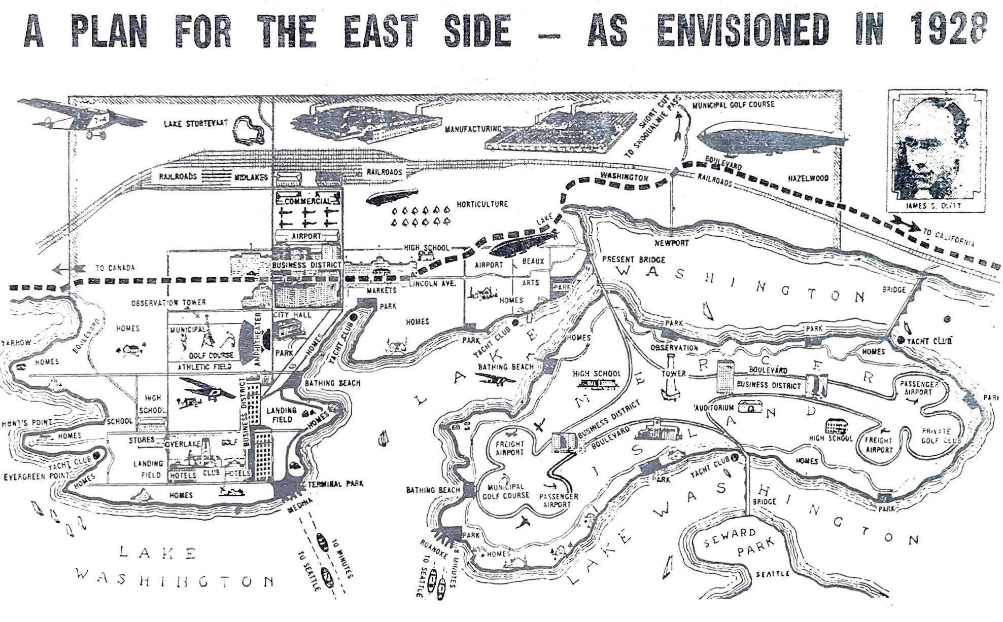
L 84.028.1 - Ditty City 1928 illustrated map of Bellevue - John Ditty's vision of the future.
The final stretch was indeed completed, and on June 5, 1920 an autocade traveled from Seattle’s County-City Building around the north end of the lake to Bellevue’s Wildwood Park near Meydenbauer Bay for festivities showcasing speeches by officials of the Automobile Club of Western Washington as well as past and current county commissioners. The Bellevue District Development Club had decorated the town with flags and banners, and Eastside ladies’ committees served coffee, lemonade and sandwiches. The event was hosted by the Reflector.
During the 1920s and 30s, the Seattle Star sponsored an annual 52-mile walking contest around the lake. Contestants who decided that by the time they reached Bellevue they’d had enough were offered transportation across the lake back to the City. In 1928 the male winner of the race finished the entire course in 9 hours, 24 minutes. His first-place cash prize of $250 would be worth about $4,000 today. The winning woman, a Monroe teacher, finished in 13 hours, 11 minutes. (The Seattle Times announcement did not mention whether she too received a prize.)
It is not likely that the all the roads constituting the entire route were ever known uniformly as Lake Washington Boulevard. In Seattle the Olmsted firm laid out the section running from Montlake to Seward Park along the lake shore; it is still Lake Washington Blvd. On the Eastside in 1945 a long stretch of road called Lake Washington Boulevard ran north from Renton along the lake shore to Factoria. It turned west along S.E. 32nd (which no longer exists there) and then angled diagonally across Mercer Slough to where the Winters House stands today. It followed 104th Ave. NE to today’s Main Street, where it ran west along the lake to 84th Ave. NE. At NE 28th it turned east to run along the south of Hunts Point and Yarrow Point on what is today called Points Drive to an intersection at Northup Way. Continuing north towards Hougton it was called Lake Washington Blvd until it reached the Bellevue-Kirkland boundary.
From today’s perspective, one wonders why the route didn’t simply run due north along present Bellevue Way/104th Ave. N.E. Early developer James Ditty thought the same thing. According to local history writer Lucile McDonald, when what later became Bellevue Way was just a “cow trail” called Peach Street in the late 1920s, Ditty bought 38 acres around today’s intersection of Bellevue Way and N.E. 8th St. He granted King County an easement across his property, and in 1930 the newly paved road running north toward Kirkland was renamed Lincoln Avenue.

Remnant stretch of Lake Washington Boulevard
Ditty’s property became the new nucleus of Bellevue’s commercial district. But Lake Washington Boulevard continued to meander closer to the lake shore. An almost overgrown remnant of the old paved road can still be walked between Bellevue Way and N.E. 35th Place in Clyde Hill, just south of the sound wall of SR 520. In summer prolific brambles offer up ripe blackberries for the picking.
References
Reflector editions (is this kind of resource just called EHC archives?)
Seattle Times May 20, 1928
Seattle Star, July 26, 1919 (graphic of LWB route)
Lucile McDonald, Bellevue, Its First 100 Years
Kroll Eastside map book 1945
HistoryLink Essay #10244, “Lake Washington Boulevard”


