Enatai

Three Bellevue Parks

BY margaret Laliberte, EASTSIDE HERITAGE CENTER VOLUNTEER

The Vertical File at Eastside Heritage Center is a treasure trove of original miscellany—largely newspaper clippings—organized into hundreds of topics pertaining to Eastside history.  An old-fashioned browse through a manila file is likely to turn up intriguing and unexpected tidbits for those with a love of our local history.  Take the Bellevue Parks files, for example.  Here’s a sample of some little-known and/or long forgotten stories about three Bellevue parks.

Enatai Park’s “Crater.”  The park, at 10661 S.E. 25th St., is a peaceful sanctuary of big left maple and conifers.  But to access the picnic tables and children’s play area the visitor must make a steep descent into what appears to be a deep crater.  How can this be?  An article by local historian Lucile McDonald dated October 23, 1983 (newspaper unknown) solves the mystery.  At the same time that the first floating bridge between Mercer Island and Seattle was being built in the late 1930s, crews were also improving the old roadway leading east to North Bend to create the four-lane Sunset Highway.  The local Lakeside Gravel Company excavated a large gravel deposit on the site of today’s park to provide surfacing material for the new roadway.  Once the quarry was no longer needed, the crater was used for while as a garbage dump until local residents stymied that use.  The property was sold in 1940, and in 1950 the owner sold the property to the City of Bellevue.

Brian Goldbloom’s “Ruin”

McCormick Park’s granite “ruin.”  A familiar sight in the narrow park that runs along the north side of N.E. 12th St. in downtown Bellevue, across from the Belletini residence, is the enigmatic granite construction that some might feel looks like a ruined cathedral.  Its backstory can be found in a June 23, 1989 Journal American editorial.  The sculptor, Brian Goldbloom, created numerous pieces of public art in the Pacific Northwest during that era, working mainly with natural stone materials.  According to the editorial, his vision of this creation was something that would add a sense of the past to Bellevue, which he felt is too young to have a deep sense of time and place.  He also wanted to create something that would, in his words, “draw people in so they’d want to hang around.”  Ironically, the current pandemic created the circumstances that have drawn small groups of two or three locals at a time to sit on the stone pieces of this artwork to socialize.

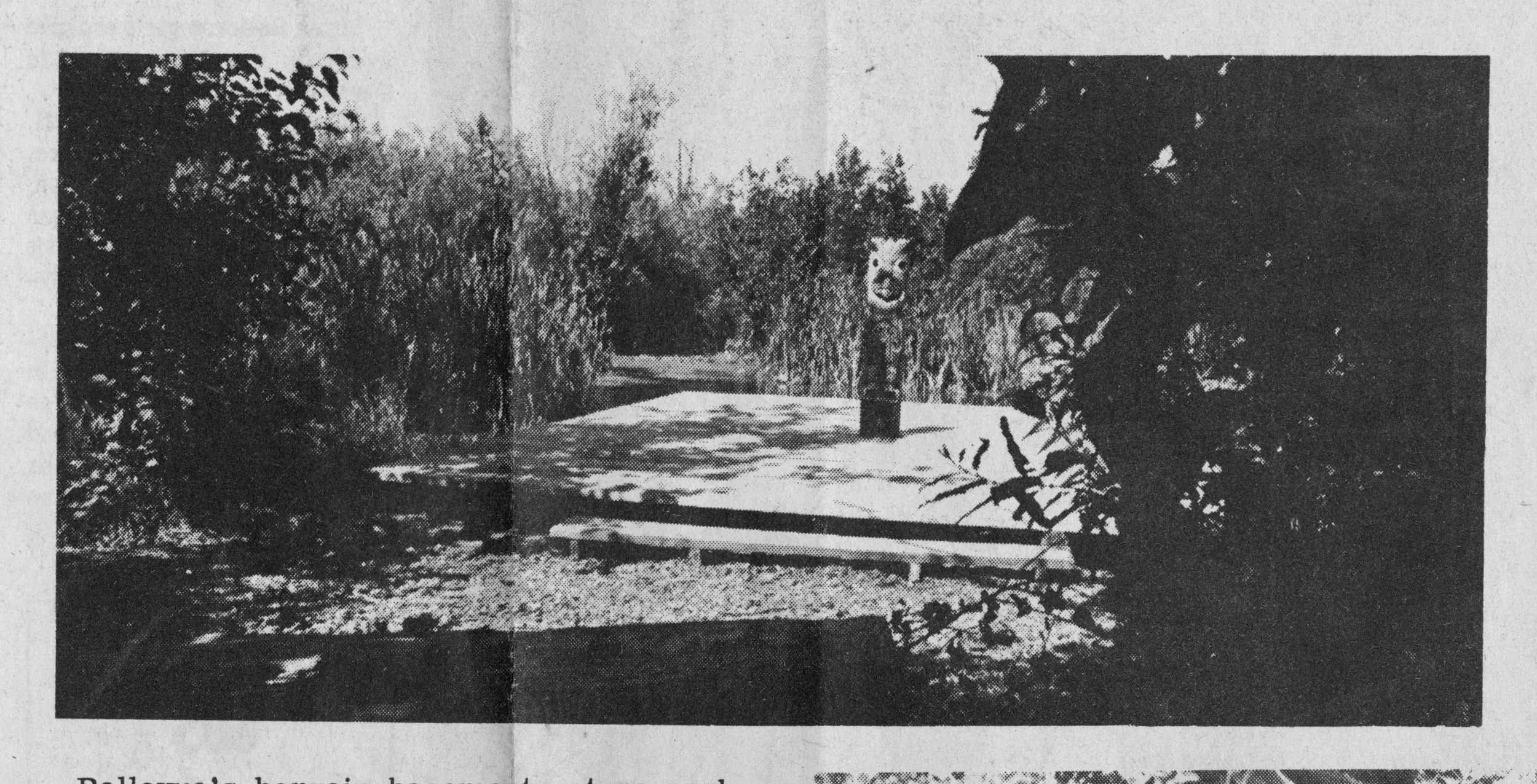
Bellefields Nature Park, Bellevue American newspaper clipping.

Bellefields Nature Park’s tikis and totem.  The separate identity of this early park has vanished today, merged into the larger Mercer Slough Nature Park. The land for the original Bellefields Nature Park, at the north end of the slough and running between 118th Ave. N.E. and Bellevue Way, was purchased by the City of Bellevue in 1957.  Because of the deep deposits of peat underlying the site, original plans to develop tennis courts and a golf course had to be shelved. As  Lucile McDonald explained in a 1983 article, “the greens would be bouncy,” and costs to develop the area would be prohibitive. So Siegfried Semrau, the city’s park’s director, decided to develop  a “nature park.” Boys from the state’s Youth Corps built a network of trails through the park over four years, earning  $25 a week for their work. A 1969 article in the Bellevue American noted that the park department’s sign maker, Earl “Bud” Baunsgard. “ has created several wood carvings… to surprise the hiker as he strolls along the trails.  Two tikis and a totem pole greet park users with a trio of brightly colored frogs.”

The tikis and totem are long gone, but a “heritage” park sign built by Baunsgard still stands in the city’s Killarney Park.

Resources

Eastside Heritage Center Archives

Eastside Stories: The Wake Robin Lodge

Eastside Stories is our way of sharing Eastside history through the many events, people places and interesting bits of information that we collect at the Eastside Heritage Center. We hope you enjoy these stories and share them with friends and famil…

Eastside Stories is our way of sharing Eastside history through the many events, people places and interesting bits of information that we collect at the Eastside Heritage Center. We hope you enjoy these stories and share them with friends and family.

Article by: Barbara Williams

Its Sunday today, so where shall we go?

To the Wake Robin Lodge, don’t you know.

Receptions, dancing and chicken for all.

Teas and music, you’ll have a ball!


The Wake Robin Lodge was the former Enatai home of Sam Krueger. It was built around the time of the First World War (1914-1918). In 1926, Mr Krueger leased the building and the land to two African-American men from Seattle: A. Cunningham and C. James. They planned to open it as a roadhouse or restaurant. It would be the first African-American enterprise on the Eastside. They named it the Wake Robin Lodge. Wake Robin is the name of our local bird, the Spotted Towhee. It is also the South Carolina name for the Trillium flower. Both the bird and the flower are indigenous and common to this area.

The new owners remodeled the building to resemble a semi-bavarian chalet with a large stone fireplace in the main room, porches, wide front steps at the entry, inside balconies around three sides, and beautiful hardwood floors throughout the building. The Lodge was totally self-sufficient. An orchard with fruit trees framed the long driveway along which Mr. Cunningham often drove his shiny Nash car with wooden spoke wheels. There were chicken sheds, a water tank, a dairy and large vegetable garden. Almost everything that went on the tables was produced on-site. Not only that, being at the top of the hill, the building sported a lovely view to the east ..... the perfect destination for a day in the country.

When the two men opened the Lodge for business on Saturday, February 19, 1927, people were curious to sample the new restaurant. Word went out about the delicious chicken dinners, fresh vegetables and fruit, music and dancing, as well as, teas, receptions and celebrations. Visitors came flocking by ferry boat and automobile from places like Seattle and the surrounding towns to enjoy a good time. The Lodge was located just south of the junction of the paved Lake Washington Highway (Bellevue Way SE) and the Mercer Island Enatai road (108th Avenue SE) with a turn onto the long driveway (presently, SE 23rd Street). Sunday full course chicken dinners were served from 2 pm to 9 pm for $1.50 per plate. To make reservations visitors could phone: Lakeside 126. The food was delicious and the waiters, excellent. Waiters were older African American men and sometimes students from Garfield High School in Seattle. The students usually took the Leschi to Medina ferry. They worked late at night washing dishes and making five dollars a night.

Bellevue High School celebrated its 1933/1934 Junior-Senior banquet at the Wake Robin Lodge. Many celebrations happened at the Lodge including the wedding reception of Miss LaReine Renfro to Mr. Roland Putnam Burnham on June 30, 1934.

This special country inn situated just up the hill from Cecilia and Frederick Winters’s home and floral business on Bellevue Way SE, was a very popular outing for many people. However, when the Great Depression hit the country between the years of 1929 to 1933, it affected businesses such as the Wake Robin Lodge. People no longer had the money to eat out and the business began to flounder. Soon it closed. The property was then held by The Home Savings and Loan Association and the Lodge sat empty for many years. During that time, Leila Cook Martin and her sister, who grew up next door to the Lodge, loved to explore the grounds and buildings. With permission from their parents, they took their roller skates and skated around the wonderful hardwood floors. The doors were never locked and a Mr. Jones was caretaker of the white leghorn chickens. By 1941 the building was torn down. State Senator, Al Thompson bought the property. The Thompson family built a large house close to where the Lodge had stood and the land was subdivided. Today there are multiple houses in the area. The driveway is labeled SE 23rd Street and there is a sign at a loop in the road that reads “Wake Robin Farm Crescent”. So the Wake Robin Lodge and it’s people live on and with more research it’s light will become brighter and more colorful.

Photo: Aerial view showing the Winters house (light colored building on Bellevue Way SE) and the Wake Robin Lodge building (dark roof, lower left)

Photo: Aerial view showing the Winters house (light colored building on Bellevue Way SE) and the Wake Robin Lodge building (dark roof, lower left)

Resources:

Eastside Heritage Center Vertical File of newspapers and other ephemera

Book: Culinary History of a Pacific Northwest Town by Suzanne Knauss, 2007

Writings by Leila Cook Martin and her brother, Bill

Photographs:  Eastside Heritage Center data base, Barb Williams